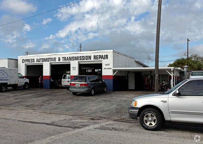
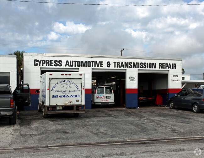
Property Record
1402 Cypress Ave, Melbourne, FL 32935
NEARBY LISTINGS FOR SALE OR LEASE
Property Detail
1402 Cypress Ave
Palm Bay-Melbourne-Titusville, FL
Eau Gallie, Village Plat Of
27-37-16-25-00055.0-0011.00
EAU GALLIE, VILLAGE PLAT OF LOTS 11, 12 BLK 55
Autorepair
Brevard
X
Florida
12009C0519H
11
2024
0.40 AC
2025
Brevard County
064202
Orlando
1,781 SF
DEMOGRAPHICS near 1402 Cypress Ave
1 Mile
3 Mile
5 Mile
2024 Total Population
6,566
51,225
131,730
2029 Population
7,195
55,729
143,658
Pop Growth 2024-2029
+ 9.58%
+ 8.79%
+ 9.05%
Average Age
43
44
45
2024 Total Households
2,902
22,958
56,728
HH Growth 2024-2029
+ 9.37%
+ 8.60%
+ 8.87%
Median Household Inc
$53,074
$62,098
$67,829
Avg Household Size
2.20
2.10
2.20
2024 Avg HH Vehicles
1.00
2.00
2.00
Median Home Value
$228,855
$242,634
$289,869
Median Year Built
1972
1980
1982
Nearby Places
Map Layers
Map Styles
 Street
 Aerial
- Restaurants
- Banks
- Shops
- Fitness
- Groceries
PUBLIC TRANSPORTATION
AIRPORT
Melbourne Orlando International
DRIVE
WALK
Distance
Melbourne Orlando International
12 min
4.9 mi
Freight Ports
Port Canaveral
DRIVE
WALK
Distance
Port Canaveral
42 min
23.4 mi
Nearby Properties
Address
Land Use
TOTAL SIZE
Lot Size
Zoning
Address
Land Use
TOTAL SIZE
Lot Size
Zoning
475,791 SF
229.02 AC
M1
Address
Land Use
TOTAL SIZE
Lot Size
Zoning
265,272 SF
21.17 AC
M1
Address
Land Use
TOTAL SIZE
Lot Size
Zoning
265,062 SF
14.75 AC
M1
Address
Land Use
TOTAL SIZE
Lot Size
Zoning
363,826 SF
25.61 AC
RA
Address
Land Use
TOTAL SIZE
Lot Size
Zoning
332,802 SF
37.02 AC
I1
Address
Land Use
TOTAL SIZE
Lot Size
Zoning
672 SF
57.80 AC
I1
Address
Land Use
TOTAL SIZE
Lot Size
Zoning
197,734 SF
27.99 AC
M1
Address
Land Use
TOTAL SIZE
Lot Size
Zoning
269,111 SF
21.79 AC
PUD
Address
Land Use
TOTAL SIZE
Lot Size
Zoning
289,263 SF
13.96 AC
R2
Address
Land Use
TOTAL SIZE
Lot Size
Zoning
280,518 SF
13.88 AC
Address
Land Use
TOTAL SIZE
Lot Size
Zoning
328,357 SF
34.11 AC
I1
Address
Land Use
TOTAL SIZE
Lot Size
Zoning
295,347 SF
14.61 AC
R2
Address
Land Use
TOTAL SIZE
Lot Size
Zoning
225,168 SF
7.06 AC
R3
Address
Land Use
TOTAL SIZE
Lot Size
Zoning
222,779 SF
22.58 AC
R2
Address
Land Use
TOTAL SIZE
Lot Size
Zoning
188,237 SF
13.97 AC
R2
Address
Land Use
TOTAL SIZE
Lot Size
Zoning
253,120 SF
16.02 AC
R2
Address
Land Use
TOTAL SIZE
Lot Size
Zoning
207,405 SF
28.05 AC
R26
Address
Land Use
TOTAL SIZE
Lot Size
Zoning
226,121 SF
17.73 AC
Address
Land Use
TOTAL SIZE
Lot Size
Zoning
225,020 SF
24.25 AC
Address
Land Use
TOTAL SIZE
Lot Size
Zoning
74,716 SF
366.45 AC
M1
Address
Land Use
TOTAL SIZE
Lot Size
Zoning
364,027 SF
22.91 AC
C2
Address
Land Use
TOTAL SIZE
Lot Size
Zoning
182,494 SF
8.53 AC
CCP
Address
Land Use
TOTAL SIZE
Lot Size
Zoning
205,564 SF
14.56 AC
M1
Address
Land Use
TOTAL SIZE
Lot Size
Zoning
175,610 SF
10.01 AC
CCP(15)
Address
Land Use
TOTAL SIZE
Lot Size
Zoning
159,590 SF
26.66 AC
R26
Address
Land Use
TOTAL SIZE
Lot Size
Zoning
252,942 SF
29.76 AC
R3
Address
Land Use
TOTAL SIZE
Lot Size
Zoning
188,093 SF
13.11 AC
R2
Address
Land Use
TOTAL SIZE
Lot Size
Zoning
672 SF
261.50 AC
M1
Address
Land Use
TOTAL SIZE
Lot Size
Zoning
225,781 SF
11.86 AC
R2
Address
Land Use
TOTAL SIZE
Lot Size
Zoning
131,585 SF
10 AC
R2
The World's #1 Commercial Real Estate Marketplace
Connect with us
© 2025 CoStar Group
The information above has been obtained from sources believed reliable. While we do not doubt its accuracy we have not verified it and make no guarantee, warranty or representation about it. It is your responsibility to independently confirm its accuracy and completeness. Any projections, opinions, assumptions, or estimates used are for example only and do not represent the current or future performance of the property. The value of this transaction to you depends on tax and other factors which should be evaluated by your tax, financial, and legal advisors. You and your advisors should conduct a careful, independent investigation of the property to determine to your satisfaction the suitability of the property for your needs.